Posted on 4 Comments

New app and firmware update available!

App-Icon with Badge

A couple of weeks ago we published a new app update for iOS and Android. Not only does it fix many bugs and improves overall performance and stability, it also includes a first firmware update for your Unleashed. This firmware update will fix all known bugs and issues that were caused by, or had something to do with the firmware on the Unleashed. Check out our forum entry “What are UNLEASHED’s 1.0 known issues?” to get detailed infos on what’s exactly been fixed.

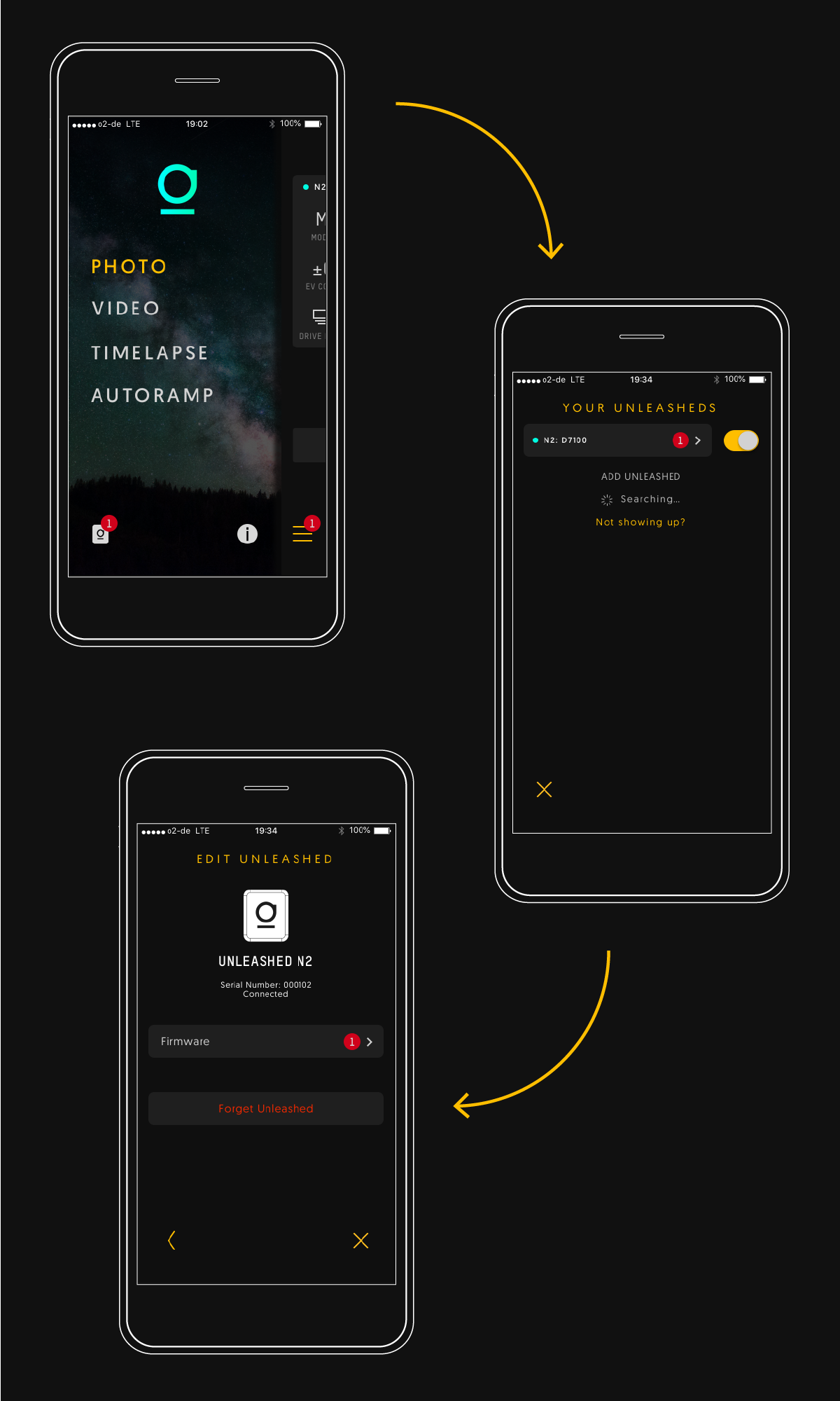
In case you haven’t done the update yet, here’s a quick explanation. To get the firmware update you need to update the app first. Once you did this, the update will be available in your Unleashed profile in the app. To install the firmware update, make sure the Unleashed is plugged in, the camera is turned on and the app is connected. Tap “Install Update” and the magic happens. Updating will take about two minutes and once it’s done, a big checkmark will appear. For all Canon users: Please keep your camera “awake” by half-pressing the shutter button of the camera every ten seconds. This is necessary so the Unleashed gets power.

Unleashed App Screens

We are continuously working on the Unleashed and are planning to provide app and firmware updates on a regularly basis. The next update will probably include new features that we will announce at some point in the future.

If you have any feedback, please let us know. You can either have a look at our forum or write us an email to our info@ address. Thanks for your on-going support. Let’s continue to make a great product even greater! :-)

Posted on Leave a comment

foolography partners with Triggertrap


We are proud to announce a cooperation between foolography and Triggertrap. That’s right, we’re making our Unleashed compatible with the Triggertrap app, and the Triggertrap app compatible with the Unleashed! So every one of you backers can use both our app as well as all the cool triggering features of the Triggertrap app that you might already be used to, but now wirelessly with your Unleashed!

Posted on Leave a comment

Adobe Lightroom 4 released – with extensive Geotagging support

More and more software is coming out with support for geotagged photos. Finally Adobe has caught on, and has released Lightroom 4, along with pretty decent geotagging features.

Lightroom 4 Senegal Map

“Map” is now one of the main views available in Lightroom, in which you will see a big map, with markers in all the spots on the map in which you took photos. If you zoom out, markers too close together are merged. Instead of an empty marker representing a single photo, a number is displayed on that marker, indicating the number of photos taken in that area. You can also choose to load GPS tracklog files, and have Lightroom 4 display these on the map. These tracks can even be used to indirectly geotag photos that are not yet geotagged, by matching the timestamps.

Lightroom 4 tracklogs

Optionally, you can blend in extra panels. The left panel contains three subviews:

  • Navigator – a smaller overview map
  • Saved Locations – a set of manually saved spots/areas, defined by location and radius. For each Location you can set a privacy option, if you want location metadata to be deleted whenever you export photos from this area (your home, for example)
  • Collections – what would be called “Albums” in most other Photo Managment software – not geotagging specific.

The right panel is your usual Metadata panel, in which you can see EXIF, IPTC and other Metadata, including the EXIF Fields with the GPS coordinates, along with button that will center the map to those coordinates. You can even choose to only display Location Metadata.

Along the bottom you have your film-strip panel. The photos in here all have badges in the bottom right corner, indicating whether or not they are geotagged. if you click on one of the markers in the map view, all the photos in that location are centered and highlighted in the film-strip view, so you can quickly see which photos were taken there. Instead of clicking on a single marker in the map, you can also apply one of three Location filters (along the top of the map view):

Lightroom 4 location filter

  • Visible on Map – highlights all photos in the filmstrip which were taken in the currently visible area on the map.
  • Tagged – highlights all photos in the filmstrip that are geotagged, and dims the photos without geotag
  • Untagged – does exactly the opposite.
The latter is especially useful for finding the photos where your geotagging device missed a photo or two without you noticing, so that you can manually add its location – for example by synching Location metadata from another photo taken in the same spot, or using a tracklog that you might have additionally saved.

I have not taken the time to dive any deeper into Lightroom 4 (I use Apples Aperture – which has supported geotagging for quite a while longer), who knows what other gems I might have missed – so feel free to add your own finds in the comments!

Posted on Leave a comment

Apple releases Aperture 3 with geotagging – places

Finally, Apple has brought geotagging to Aperture. Along with over 200 other new features, “Places” is now part of Aperture 3. I haven’t tried it yet, but it sure looks worth it! Read more on the apple website

Places in Aperture 3
Image by Apple

If you want the exact details, check out this page and this page

If you prefer watching a video, Apple provides that too.

Posted on Leave a comment

Improved geotagging in Picasa 3.5

On September 22nd, Google released a new version of Picasa. Of course, the most interesting improvement being enhanced geotagging.

Picasa 3.5 screenshot

The new “Places” button shows an integrated Google Maps window, on which the positions of your (currently selected) geotagged photos are shown as pins, and onto which you can drag other photos, in order to manually geotag them. Read more here

Posted on Leave a comment

iPhoto 09 with geotagging support

Apple announced iPhoto 09 as part of iLife 09 today, which brings lots of geotagging support to mac users. For those unfamiliar with it, iPhoto is a very popular photo managing and editing software. The new version has a feature Apple calls “Places”, which makes use of geotags in photos. You can sort and search your images by location, either in a list of places or on a map you can zoom into.

This means that the advantages of geotagging will now become evident to many more photographers, and since most other software companies are going to follow Apples lead, watch out for a boom in geotagging support this year!

Don’t forget: iPhoto only makes use of geotagged photos, you still need to actually geotag them first, for example using foolography products.